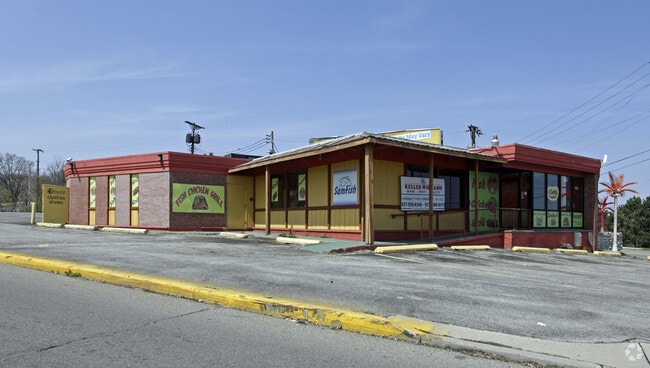
Property Record
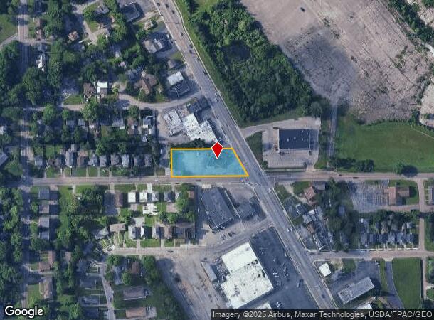
4301 N Main St, Dayton, OH 45405
Current Lease Availabilities
NEARBY LISTINGS FOR SALE OR LEASE
Property Detail
4301 N Main St
E20-01008-0069
4-5-17
Storebuilding
Montgomery
X
Ohio
39113C0161E
69
2023
0.81 AC
2024
North Dayton
080300
Cincinnati/Dayton
6,444 SF
Dayton, OH
DEMOGRAPHICS near 4301 N Main St
1 Mile
3 Mile
5 Mile
2024 Total Population
10,432
77,585
167,416
2029 Population
10,454
78,644
169,524
Pop Growth 2024-2029
+ 0.21%
+ 1.36%
+ 1.26%
Average Age
41
40
40
2024 Total Households
4,858
33,879
72,981
HH Growth 2024-2029
+ 0.10%
+ 1.22%
+ 1.21%
Median Household Inc
$41,883
$39,458
$39,402
Avg Household Size
2.00
2.20
2.20
2024 Avg HH Vehicles
1.00
1.00
1.00
Median Home Value
$90,298
$84,019
$95,598
Median Year Built
1955
1955
1957
Nearby Places
- Restaurants
- Banks
- Shops
- Fitness
- Groceries
PUBLIC TRANSPORTATION
AIRPORT
James M Cox Dayton International
DRIVE
WALK
Distance
James M Cox Dayton International
16 min
8.3 mi
Freight Ports
Port of Toledo
DRIVE
WALK
Distance
Port of Toledo
175 min
151.2 mi
Nearby Properties
Address
Land Use
TOTAL SIZE
Lot Size
Zoning
Address
Land Use
TOTAL SIZE
Lot Size
Zoning
923.52 AC
Address
Land Use
TOTAL SIZE
Lot Size
Zoning
127,232 SF
7.96 AC
Address
Land Use
TOTAL SIZE
Lot Size
Zoning
22,133 SF
47.58 AC
Address
Land Use
TOTAL SIZE
Lot Size
Zoning
573,962 SF
1,128.84 AC
Address
Land Use
TOTAL SIZE
Lot Size
Zoning
5.92 AC
Address
Land Use
TOTAL SIZE
Lot Size
Zoning
144,340 SF
91.38 AC
Address
Land Use
TOTAL SIZE
Lot Size
Zoning
20.16 AC
Address
Land Use
TOTAL SIZE
Lot Size
Zoning
170,977 SF
8.65 AC
Address
Land Use
TOTAL SIZE
Lot Size
Zoning
100,716 SF
4.31 AC
Address
Land Use
TOTAL SIZE
Lot Size
Zoning
505,736 SF
45.42 AC
Address
Land Use
TOTAL SIZE
Lot Size
Zoning
313,421 SF
19.55 AC
Address
Land Use
TOTAL SIZE
Lot Size
Zoning
634,508 SF
24.36 AC
Address
Land Use
TOTAL SIZE
Lot Size
Zoning
99,601 SF
15.58 AC
Address
Land Use
TOTAL SIZE
Lot Size
Zoning
10.87 AC
Address
Land Use
TOTAL SIZE
Lot Size
Zoning
509,060 SF
31.03 AC
Address
Land Use
TOTAL SIZE
Lot Size
Zoning
6.25 AC
Address
Land Use
TOTAL SIZE
Lot Size
Zoning
1,189,046 SF
45.07 AC
Address
Land Use
TOTAL SIZE
Lot Size
Zoning
23.29 AC
Address
Land Use
TOTAL SIZE
Lot Size
Zoning
6.57 AC
Address
Land Use
TOTAL SIZE
Lot Size
Zoning
8.98 AC
Address
Land Use
TOTAL SIZE
Lot Size
Zoning
101,698 SF
19 AC
Address
Land Use
TOTAL SIZE
Lot Size
Zoning
243,256 SF
13.58 AC
Address
Land Use
TOTAL SIZE
Lot Size
Zoning
46,592 SF
5.32 AC
Address
Land Use
TOTAL SIZE
Lot Size
Zoning
17.54 AC
Address
Land Use
TOTAL SIZE
Lot Size
Zoning
263,022 SF
19.33 AC
Address
Land Use
TOTAL SIZE
Lot Size
Zoning
57,467 SF
5.33 AC
Address
Land Use
TOTAL SIZE
Lot Size
Zoning
68,196 SF
3.55 AC
Address
Land Use
TOTAL SIZE
Lot Size
Zoning
92,782 SF
12.44 AC
Address
Land Use
TOTAL SIZE
Lot Size
Zoning
10.06 AC
Address
Land Use
TOTAL SIZE
Lot Size
Zoning
71,363 SF
4 AC
The World's #1 Commercial Real Estate Marketplace
Connect with us
© 2025 CoStar Group
The information above has been obtained from sources believed reliable. While we do not doubt its accuracy we have not verified it and make no guarantee, warranty or representation about it. It is your responsibility to independently confirm its accuracy and completeness. Any projections, opinions, assumptions, or estimates used are for example only and do not represent the current or future performance of the property. The value of this transaction to you depends on tax and other factors which should be evaluated by your tax, financial, and legal advisors. You and your advisors should conduct a careful, independent investigation of the property to determine to your satisfaction the suitability of the property for your needs.